
UAV Drone & LiDAR Mapping
UAV Drone & LiDAR Mapping
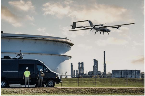
BVLOS (Beyond Visual Line of Sight) Drone Operations
LSYSTEMS is the country’s first provider of BVLOS drone operations – enabling flights beyond the visual line of sight, setting a new standard in advanced drone surveying.
LSYSTEMS delivers high-precision aerial mapping using advanced UAV drone platforms and LiDAR technology. These solutions allow rapid data collection across large and complex environments while maintaining exceptional accuracy.
Our drone and LiDAR surveys produce detailed orthomosaic maps, digital elevation models, and terrain data that support mining operations, infrastructure development, land management, and environmental monitoring. By combining aerial photogrammetry and laser scanning technologies, LSYSTEMS provides reliable geospatial data that improves planning, monitoring, and project execution.
Inspection Capablities Such as:
Tower Inspections
LSYSTEMS provides advanced drone-based inspection services for communication and power transmission towers. Using high-resolution visual and thermal imaging, we identify structural issues such as corrosion, loose components, and vegetation interference quickly and safely—without the need for manual climbing or shutdowns.
Tunnel Inspections
Our drone inspection solutions enable safe and detailed assessment of tunnels, including mining and road infrastructure. We capture high-quality visual and LiDAR data to detect cracks, water ingress, and structural damage, ensuring accurate reporting while minimizing operational risks and downtime.
Drone Lifting
LSYSTEMS offers drone lifting and heavy payload transport solutions for remote and hard-to-access locations. Our UAV systems can safely carry equipment, tools, and materials, supporting construction, mining, and infrastructure projects where traditional access is difficult, costly, or unsafe.
Agriculture Farming
LSYSTEMS provides drone-based agricultural solutions to support modern farming practices. From crop spraying and monitoring to aerial mapping, our services help improve productivity, reduce resource usage, and enable efficient farm management across large and challenging terrains.